Choosing the right property survey type can save developers thousands of dollars and prevent costly delays. A survey is one of the first steps in any development project, yet many property owners order the wrong type. Wasting time and money on information they don’t need, or missing critical data for their next phase of work, is common. This guide walks you through five key factors that determine which survey your property actually needs.
Start With Your Goal, Not the Survey Type
Your survey type depends entirely on what you plan to do with the property. Buying land, subdividing, obtaining permits, or resolving boundary disputes each require different survey services.
Don’t pick a survey based on what your neighbor has done. Pick it based on what you’re trying to accomplish. Your goal is the anchor. Everything else follows.
Common property goals include:
- Purchasing vacant land or an existing parcel
- Planning construction or development projects
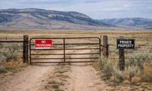
- Resolving boundary line disputes with neighbors
- Dividing land among multiple owners or heirs
- Applying for building permits with local authorities
- Documenting completed improvements or structures
Once you identify your primary goal, surveyors can recommend a specific service that matches that need. Trying to reverse-engineer the right survey without understanding your objective leads to expensive mistakes.
How Property Characteristics Influence Survey Selection
Property size, terrain, zoning, existing improvements, and location all affect which survey type is appropriate and how much it will cost.
Your property’s physical and legal characteristics shape which survey makes sense. Two developers purchasing adjacent parcels might need completely different surveys. Even if their budgets are similar, their needs differ.
Key factors that matter:
Size and Terrain. Large properties with complex topography are common in varied landscapes. They may require more intensive fieldwork than flat, compact lots. Surveyors charge more for difficult terrain and larger areas.
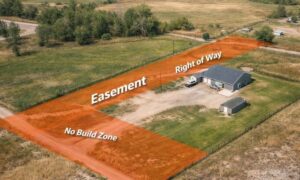
Existing Improvements. If your property has structures, utilities, or easements, the surveyor needs to document them. A vacant lot is faster and cheaper to survey than one with existing buildings.
Zoning and Development Status. Properties in active development zones or with existing permits need more detailed boundary and improvement documentation. Raw land in agricultural zones may require less intensive work.
Location Within Wyoming. Rural properties in northwestern Wyoming behave differently from properties near Jackson or Cheyenne. Local topography, weather conditions, and record-keeping practices influence survey complexity and timeline.
Title and Historical Records. Properties with murky ownership histories or missing deed records require additional research and fieldwork to establish accurate boundaries.
Matching Common Property Scenarios to the Right Survey
Different property situations require different survey types. Boundary surveys work for purchases. Subdivision surveys work for dividing land. Improvement location surveys work for construction. Title surveys work for resolving disputes.
Let’s walk through real scenarios.
Scenario 1: You’re Buying Vacant Land
A boundary survey is your baseline. It establishes property lines, identifies any easements or encroachments, and confirms that the land matches the legal description in the deed. Most lenders and title companies require this before financing a purchase. Cost range: $800 to $2,500 depending on acreage.
Scenario 2: You’re Planning Commercial or Residential Development
You’ll need a more detailed survey that includes topography, utilities, existing structures, and zoning information. Some developers use a “survey for platting.” This combines boundary data with site plan details for permit applications. Cost range: $2,000 to $6,000 or more.
Scenario 3: You’re Dividing Land Among Multiple Owners
A subdivision or lot split survey is required. This creates new legal descriptions and boundaries for each parcel, which must be recorded with the Wyoming county assessor. You’ll need a licensed surveyor to prepare and file this work. Cost range: $1,500 to $4,000 depending on complexity.
Scenario 4: You’re Resolving a Boundary Dispute
A detailed boundary survey with legal research is your tool. The surveyor investigates deeds, previous surveys, and field evidence to establish accurate lines. This work is more expensive because it involves research and expert interpretation. Cost range: $2,500 to $7,000 or more.
Scenario 5: You’re Documenting Completed Construction
An improvement location or as-built survey confirms that structures match the approved plans and sit within property boundaries. Lenders and local authorities often request this before releasing final funds or closing out permits. Cost range: $1,000 to $3,500.
Key Information to Gather Before Contacting a Surveyor
Prepare your deed, title documents, previous surveys, legal description, and project timeline before calling a surveyor. This information speeds up the process and helps surveyors quote accurate prices.
When you reach out to a surveyor, have these documents ready.
- Current deed and title report. These show ownership and any recorded easements or liens.
- Legal description of the property. Found in your deed or county records. Surveyors use this to locate and identify your parcel.
- Previous surveys, if any. Old surveys provide baseline data and can reduce fieldwork time.
- Zoning designation and land use plans. Local planning documents affect what the surveyor needs to map.
- Any existing permits or development plans. Show the surveyor what you’re planning so they can recommend the most useful survey scope.
- Timeline for your project. Surveyors schedule work based on your deadline. Be realistic about when you need results.
Having this information on hand accelerates the process and prevents back-and-forth requests that delay your project.
Planning Ahead to Avoid Unnecessary Surveys and Delays
Selecting a survey that covers both your current and future needs saves money. A site plan survey used for permitting can also serve construction stakeout later. This avoids duplicate costs.
Many developers discover too late that their first survey didn’t capture data they needed for the next phase. This leads to ordering another survey. Plan strategically instead.
Questions to ask yourself:
- Will you need permits? Then include utility and improvement mapping upfront.
- Are you subdividing? Start with a survey that supports lot split work.
- Are you constructing soon? Coordinate your boundary survey with a site plan so the surveyor captures both in one project.
- Are you selling or refinancing? Title lenders have specific survey requirements. Ask them before ordering work.
Coordinate with your lender, architect, and local planning department early. They tell you exactly what the survey needs to show. One comprehensive survey that serves multiple purposes beats two or three partial surveys that leave gaps.
Wyoming’s development timelines often stretch due to distance and weather. Ordering the right survey the first time prevents setbacks. Incorrect or incomplete surveys delay permits, trigger lender holdups, and push closing dates back by weeks or months.