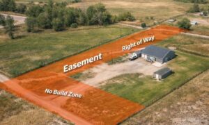

If you’re planning a commercial property deal, chances are you’ll hear the phrase alta land title survey before closing. It’s not just a map of the property. It’s a detailed document that lenders, title companies, and attorneys rely on to confirm boundaries, easements, access rights, and—something many people forget—utilities.
Utility records often become the hidden hurdle in an ALTA. Without them, surveyors can’t show underground lines on the plat, title companies hesitate to insure, and closings can drag on. The good news? You can avoid delays if you know where to start and how the process works in Cheyenne.
Why Utility Records Matter in an ALTA Survey
Imagine buying a property, only to find out later that a water main runs right through the corner where you planned to build. Or worse, discovering an unmarked utility line that prevents you from getting permits. Utility records help expose those risks before money changes hands.
That’s why Table A, Item 11(b) of the ALTA/NSPS standards focuses on underground utilities. It requires surveyors to show evidence from utility companies and recorded documents, not just what they see in the field. This makes your survey stronger and your investment safer.
Step One: Start with the Title Commitment
Every ALTA survey begins with a current title commitment. In Cheyenne, that document will list easements, rights-of-way, and utility corridors recorded with the county. Some easements cover wide areas with no exact location—these are called blanket easements. Others are tied to specific coordinates.
By reviewing this first, your surveyor knows which utilities to chase down. It’s the roadmap for the entire record search.
Step Two: Water and Sewer from the City of Cheyenne BOPU
Cheyenne’s Board of Public Utilities (BOPU) manages the city’s water and sewer system. If your property is inside the service area, this is the first stop.
Here’s what surveyors request:
- Service maps or as-builts that show water mains and sewer lines
- Tap cards that record property connections
- Main sizes and flow direction
- Manhole rim and invert elevations
Sometimes properties sit outside the city’s service area. In those cases, BOPU will note that no records exist. That information still belongs on the ALTA survey because it proves due diligence was done.
Step Three: Electric and Gas from Black Hills Energy
Most of Cheyenne’s power and gas lines are managed by Black Hills Energy, also known locally as Cheyenne Light, Fuel & Power. They provide developers and surveyors with facility information through their builder and developer portal.
The key details requested include:
- Feeder maps
- Service laterals
- Utility disclaimers (since some records are only approximate)
For clients, this is where expectations matter. Utility companies often say their records are “for reference only.” That means surveyors still confirm with field evidence and locations. But having those maps helps lenders understand the bigger picture.
Step Four: Don’t Forget Telecom and Cable
Utility research often stalls here. Telecom providers—like Spectrum or Lumen—don’t always release detailed plant maps. When that happens, surveyors document the request and turn to field locations through 811.
If you’re the client, this can be frustrating. But remember, the surveyor’s job is to show they asked, not to force a private company to share data. What matters most is that the effort is documented, and the field marks are tied to the plat.
Step Five: Call 811—One-Call of Wyoming
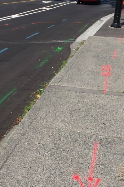
No ALTA survey is complete without a call to 811. In Wyoming, the system requires at least two business days’ notice before utility locators visit the property. Surveyors usually coordinate white-lining (spray paint or flags marking where they plan to dig or measure) so locators can respond accurately.
Each ticket number generated by 811 is saved and referenced in the survey file. For you, that’s proof the team went through the proper channels to protect underground lines.
Step Six: County Records and Corner Control
To tie everything together, surveyors rely on county data. In Laramie County, that includes PLSS (Public Land Survey System) corner records and GIS maps. Pulling these records ensures the ALTA survey lines up with legal section corners, which makes it defensible in court if a dispute arises.
Surveyors also use the Laramie County Clerk’s iDoc Market to search deeds and utility easements dating back to 1985. By citing instrument numbers directly on the plat, the survey becomes lender-ready and title-backed.
Step Seven: What If Records Are Missing?
Even with all the right requests, not every utility will provide maps. Some lines are abandoned, others undocumented, and a few companies may refuse to share. In those cases, ALTA standards allow surveyors to note the limitation directly on the plat.
This transparency protects you. It shows that the surveyor asked, but the data was unavailable. Lenders prefer this honesty over silence because it proves the issue was considered, not ignored.
How This Affects Your Closing
Utility records can add days—or weeks—to a survey if you start late. That’s why the smartest step is to order your ALTA survey as soon as the deal begins. Giving your surveyor time to contact BOPU, Black Hills Energy, telecom companies, and 811 makes the process smoother.
If you wait until closing week, missing utility records can stop the deal cold. No lender wants to fund a property with unknown underground risks.
Pro Tip: Let Professionals Handle the Utility Chase
As a client, you don’t need to call utility companies yourself. Licensed surveyors already know the right departments, forms, and requests. In fact, they often keep templates ready to send to each agency. Some firms even prepare “utility request packs” so nothing falls through the cracks.
By trusting your surveyor with this process, you save time and avoid confusion. Plus, the results land directly in the hands of the person drafting your plat.
Final Thoughts
An alta land title survey is only as strong as the records behind it. In Cheyenne, that means reaching out to the Board of Public Utilities, Black Hills Energy, telecom providers, 811, and Laramie County offices. Each source adds a layer of protection for your investment.
For property buyers, lenders, and developers, the message is simple: don’t let missing utility records delay your project. Order your survey early, give your surveyor room to request records, and ask questions if you’re unsure.
At the end of the day, it’s not just about checking boxes. It’s about knowing exactly what lies beneath your property—and making sure your deal closes without surprises.