A new pipeline plan in Wyoming is getting a lot of attention. Even if the route does not pass right through Casper, it shows a problem that happens often in local land deals. Many buyers think they are getting full use of a property. Later, they find out that parts of the land cannot be used the way they planned. This is often because of easements, access paths, or older agreements tied to the land. This is where an alta survey becomes important, especially before buying land that looks open and easy to use.
What the Pipeline Situation Reveals About Land Use
Big projects like pipelines do not always use new land. They often follow paths that already exist. These paths may include shared spaces, old agreements, and long-term access rights. Some of these have been in place for many years.
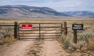
The problem is that these details are not always easy to see. A piece of land may look clear when you visit it. There may be no signs or markers. But below the surface or on paper, there may be rules about how that land can be used.
This creates a gap between what people see and what is allowed. The pipeline story helps show that land is not always as simple as it looks.
Why This Matters for Casper Property Deals
Casper is part of a busy area for energy and industry. Because of this, many properties have older easements or access rights. These may have been added long ago and still affect the land today.
A buyer may look at a property and think it is perfect for a shop, storage space, or a new building. But when plans begin, problems can show up. A part of the land may already be set aside for access or future use tied to older agreements.
The buyer still owns the land. But they may not be able to use all of it the way they expected. This can change how the project moves forward.
How Easement Conflicts Affect Real Projects
These problems often appear after the deal has already started. At first, everything looks fine. Then, when the buyer begins planning, the limits become clear.
A building may need to be moved. A driveway may not work in the planned spot. The usable area may be smaller than expected. These changes can slow things down and increase costs.
Lenders may also take a closer look. If there are unclear or confusing records, they may delay approval. This can push back closing dates and create stress for everyone involved.
These issues are common, especially on land that looks simple at first.
What an Alta Survey Actually Provides
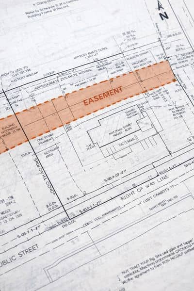
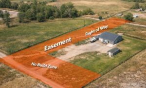
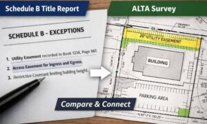
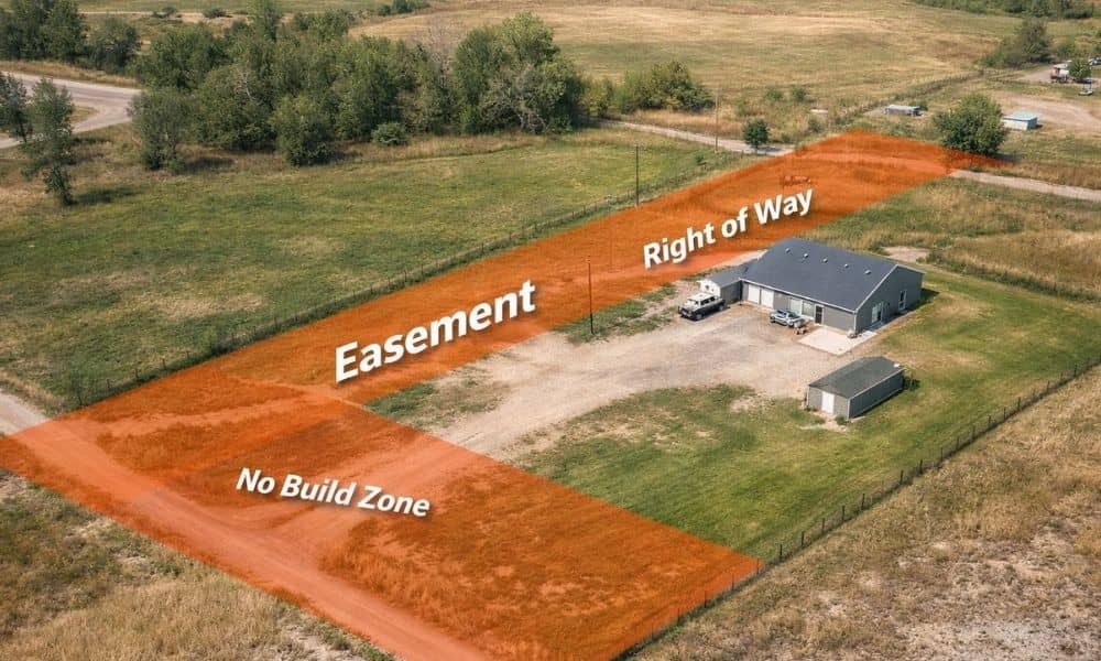
An ALTA survey shows what’s really happening on a property. It’s more than just marking the corners or lines you get a clear picture of how the land is actually used. It can highlight things like easements, access paths, and areas where restrictions might affect buildings or driveways. By looking at how an ALTA survey reveals easements on a property, buyers can see where potential issues are before they become surprises.
Having that clarity early makes it easier to plan any project on the land and helps avoid mistakes that could cost time or money later.
Why Timing Changes the Outcome
Many people wait until late in the process to get a survey. By then, they have already made big decisions. If a problem shows up, it is harder to fix.
A better approach is to start your project with accurate land data. This means getting clear information early, before plans are final.
When this happens, it is easier to adjust layouts, fix issues, and talk with lenders. It also helps avoid surprises that can delay the project.
Early information leads to better decisions.
The Difference Between Ownership and Usability
Owning land does not always mean you can use all of it freely. Easements and access rights can limit what you can build or where you can place things.
In Casper, this is something buyers should expect, not ignore. Many properties have these limits, even if they are not easy to see.
A piece of land may look open and ready to use. But that does not mean every part of it is available for building or changes.
The only way to know for sure is to look at both the records and the site together. That is what an ALTA survey is meant to do. It helps show what the land really allows, so buyers can move forward with clear information.