Many landowners in Wyoming have followed the recent corner-crossing debate. The question sounds simple at first. Can someone step from one public parcel to another if they only meet at one corner? However, once you look closer, the issue becomes more serious. Property corners are not just dots on a map. They are legal boundary points supported by measurements and records in the ground. While courts talk about access rights, buyers and lenders ask a different question: How clearly are those corners documented? That is where alta land surveys come in.
Why Corner-Crossing Matters in Wyoming
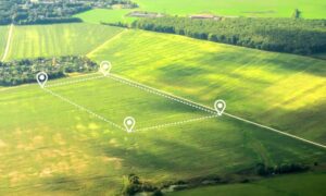
Wyoming’s land layout creates many corner situations. Long ago, surveyors divided land into square sections using a grid system. Because of that, private and public parcels often form a checkerboard pattern.
Near Casper and other rural areas, four parcels can meet at one single point. At that exact corner, ownership changes from one section to another.
Because of this layout, access questions become sensitive. If someone crosses through that single point, they may pass through private space. Therefore, the legal debate focuses on whether that action breaks ownership rights.
Although the courts decide legal meaning, the physical boundary still depends on correct measurement.
What Really Happens at a Property Corner
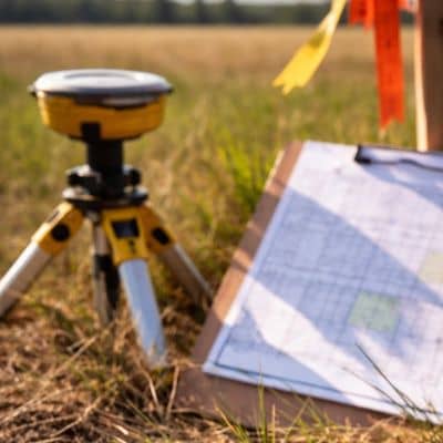
Many people think property lines are just fences. In reality, a corner is a carefully measured point tied to legal records.
Surveyors look for original markers when possible. If markers are missing, they rebuild the corner using field measurements and maps. Even small differences in measurement can shift a boundary a few inches.
That may not sound serious. However, when four parcels meet at one point, inches matter.
Because of that, accuracy becomes very important. A small mistake could place the boundary in the wrong spot. In a debate about crossing that point, precision matters.
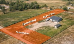
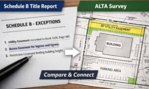
How ALTA Land Surveys Add Clarity
Basic surveys show property lines. However, alta land surveys go further. They follow national standards used by lenders and title companies. They combine field measurements with title research to give a full picture of ownership.
An alta land survey usually:
- Shows measured boundary lines
- Identifies corner markers
- Lists easements and rights-of-way
- Matches findings to title documents
- Maps buildings or fences near boundary lines
Because of this detail, alta land surveys show exactly how parcels meet at corners.
The corner-crossing debate shows why that detail matters. While courts decide legal rights, the survey shows physical facts.
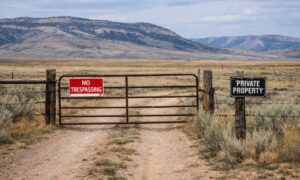
Access Is Not the Same as Ownership
One key lesson from this ruling is the difference between owning land and having access.
Owning land does not always give you a path across nearby land. Also, touching public land at one corner does not automatically create access rights.
Therefore, buyers must understand two ideas. First, where the boundary sits. Second, whether legal access exists.
Alta land surveys confirm where the boundary lies. They also show recorded easements that allow entry. However, they do not create new access rights.
Because of that, clear surveying helps people make better decisions.
Why This Matters for Buyers
Land near Casper often includes large rural tracts. Many properties sit next to federal land or open acreage. In these areas, checkerboard patterns appear often.
Imagine buying land that touches public land at one corner. You might assume easy access. Yet if that turns out to be wrong, problems may follow.
For that reason, many buyers order alta land surveys before closing. The survey confirms how boundaries connect and whether recorded access appears in title documents.
Clear records lower the risk of surprise.
Lenders Watch Boundary Details Closely
While landowners focus on use, lenders focus on risk.
When financing rural property, lenders review access, encroachments, and recorded rights-of-way. They want to know whether the parcel stands on its own or depends on unclear crossings.
Alta land surveys give lenders a clear and trusted format. The survey shows how corners line up and whether fences or structures cross lines.
Because of the corner-crossing ruling, lenders may now look more closely at corner intersections. Even if access is legal, they still want proof that boundaries sit where records say they do.
Legal Debates May Change, Boundaries Stay Measured
Court decisions can change over time. Access rules may shift. However, a surveyed boundary does not move because of headlines.
Accurate surveying remains the base of land ownership. Alta land surveys create a clear map that helps buyers, lenders, and title companies understand the property.
In Wyoming, where land divisions go back many years, that clarity matters.
Final Thoughts
The corner-crossing ruling started strong discussion across Wyoming. Most people talk about access rights. However, the situation also shows something else.
Property corners need clear documentation.
When parcels meet at one point, precision matters. Alta land surveys provide the clarity needed to understand how land connects, where boundaries sit, and what rights exist on record.
Before buying rural property near public land intersections, take time to confirm those details. Legal meanings may change, but measured boundaries give stability.
In the end, clear documentation protects both ownership and peace of mind.